|
Despite the fact Marvin E. Metzler went through at least 5 major sea
battles in World War II, there were many others involving ships, planes
and men of the sea service he had only heard about.
Hearing about them was not enough. Metzler wanted to know every little
detail---the number of men and ships involved; what happened to the
vessels, both of the United States and her allies, and Japan; the exact
location of the fracas, and its outcome.
He soon learned that, no matter how well intentioned a historian may be,
he often is not accurate. Reading three accounts of the same engagements
often led to three differing versions.
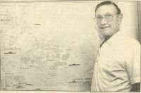
Metzler was looking for the correct version when he started his own
research several years ago. This has led to what Metzler believes is the
most authentic chart and map of the many battles fought at sea and near
the islands of the Pacific.
Metzler already was a "veteran" of naval service when World War II erupted
with the attack on Pearl Harbor. He had left the Fresno Technical High
School in July of 1937 to become a sailor, and was aboard the old USS Salt
Lake City headed for Pearl when the attack came.
Quite naturally, his chart begins with the incidents of Dec. 7, 1941. It
lists the casualties of men and ships suffered in blow, then moves on
through the engagements near Java, the Coral Sea, Guadalcanal and on to
later campaigns - Tarawa, Iwo Jima, the Philippines.
He has painstakingly researched the names of the ships, their commanding
officers, fleet leaders and their aircraft support. Many of the facts he
remembers from having been in the thick of things. Some supporting
evidence he has obtained from a brother, Lawrence, who also was in many of
the battles as a sailor.
Metzler's compendium shows the opposing naval strength of the Japanese
navy, giving the names of ships and commanding officers, as it stood on
Dec. 7, 1841. Then he follows each through the war and shows, on a
detailed map, where each met its fate.
"I had a tough time finding out where the different fleets, or units of
fleets started from before each engagement, and where they went
afterwards," he said, "But I found out, and their routes are shown on my
map."
It is natural, perhaps, that the USS Salt Lake City's whereabouts are
adequately chronicled in the Fresnan's work. He was aboard her when her
big guns were trained on Wotje in the Marshalls to begin the first
bombardment of an enemy shoreline in the war.
"We watched a Japanese torpedo sail directly under our steel bottom then
hit and sink the Wasp," he remembers.
"From her decks we saw the death blows dealt to the Hornet and the O'Brien.
We watched the North Carolina take a torpedo, then helped get her ashore."
"Thirty ships were sunk in the battle of Iron Bottom Bay off Guadalcanal
in 1942 - half of them ours and the other half theirs. This was before the
tides of the sea war turned and our side began to take the upper hand."
The exact locations of the graves of the 36 vessels are pinpointed on his
map, and so are the last resting places of the men of war involved in the
Savo Island Battles.
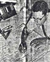
It is no coincidence that Metsler's map is a masterful bit of draftsmanship.
He currently is the chief draftsman for Fresno district headquarters of
the State Division of Highways. All day he drafts plans for highway
development, then at night he puts the finishing touches on his map at
home.
He never really learned drafting, he says. "I just grew up with it."
He left the Navy 20 years ago to make a home for his childhood sweetheart,
Venita Wilson, who became his wife. But, obviously, the navy still holds
a warm place in his heart. So does the old Salt Lake City.
He felt tears in his eyes the day the old battle scarred cruiser finally
was sunk off San Diego by units of the navy.
"She went through the atom bomb tests off Bikini, and was radioactive, so
she was sunk," he says.
The Salt Lake City's final resting place is not shown on Metzler's map.
The original of this chart was done in India Ink on linen [Copyright 1966
M. E. Metzler]. It took Marvin Metzler 3 years to research and draft the
same. The original is 40" x 38".
President George Bush, General McCain,
many Admirals, Historical Archives, and Annapolis have copies.
|